
|
|
|
|---|
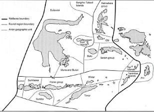
| Nusa Tenggara comprises the smallest islands in Indonesia and is divided into two provinces, Nusa Tenggara Barat (NTB) and Nusa Tenggara Timur (NTT). The largest island in NTB is Sumbawa (15,255 ha) and in NTT is West Timor (14,395). Nusa Tenggara, Maluku make up about 8% of the land area of Indonesia. Most of these islands are young, ranging from 1 to 15 million years old (Audley Charles 1987). The Nusa Tenggara islands fall into the western half of the Inner and Outer Banda arcs. The inner Banda islands tend to be mostly volcanic; some have been combined during the glacial maxima up to 10,000 years ago, into larger dry land masses (such as Komodo and Flores). These past larger island groupings have left an imprint on the faunal assemblages and the nature of intra-specific morphological and genetic variation found in the higher vertebrates that currently inhabit these modern islands (Kitchener and Suyanto 1996). |
 |
|---|
Eastern Indonesia is at the junction of four main geological plates (Indo-Australian, Pacific, Eurasian and Philippine Sea). It is the interaction between these plates that produces the complex geology and tectonic activity in Nusa Tenggara (Monk et al. 1997). Consequently, these islands are a mixture of volcanic islands, coral reef islands, continental crust fragments and composite islands formed from different sources.

The oceanic volcanic islands of the Inner Banda Arc are geologically the simplest. These include Lombok, Sumbawa, and Flores. Solor, Adonara, Pantar. Komodo is the exception amongst the Inner Banda Arc Tertiary volcanic islands as it was formed in part during the Mesozoic. Flores is a particularly unstable part of the NTT inner islands. This instability is influenced by the Banda Arc-continent collision at the Timor Trench to the south of the Flores. Flores now has 14 active volcanoes. Volcanoes further to the east of the Banda arc are increasingly younger in age (Carlile and Mitchell 1994).
The non-volcanic islands in the Outer Banda Arc are derived from the basement rocks of the Australian continental margin (Audley Charles 1993), most emerged from the sea only about 4 million years ago. These include the islands of Sumba, Raijua, Sawu, Roti, Semau and possibly Timor (Harris 1991). Whatever their origins, islands in the Banda Arc are now mainly composed of raised shallow- and deep-marine sediments, and they are characteristically limestone, with karts formations (Monk et al. 1997).
Maluku islands are generally small, like those in Nusa Tenggara. The largest islands are Halmahera (20,000 ha) and Seram (17, 429 ha); no other island is larger than 8,000 ha. Many of the islands in the southern Maluku are also part of the Banda Arc of islands. Although many of the islands in the southern Maluku were influenced and formed by geological process related to the Banda Arc, that formed the Banda Islands, much of the northern Maluku islands, including the larger islands, were formed by the contact zone between the Indo-Australian Plate and the westward movement of the Pacific Plate during the Miocene. (Hamilton 1979).
Southern Maluku volcanic islands that are part of the Inner Banda Arc include Wetar, Romang, Damar, Teun, Nila Serua, Manuk and the Banda Islands. They are all young and almost all are active and surrounded by fringing reefs of some 75 m in width (Pannell 1991). The northern part of the Inner Banda arc (part of the Buru-Seram-Ambon complex) is not active and is composed of old, eroded volcanic rocks.
Outer Banda Arc islands in the Maluku include, Kisar, Leti, Moa, Lakor, Sermata Islands, Luang, Babar Islands, Tanimbar Islands, Kai Islands, Watubela Islands, Gorong Islands and Seram Laut. They are characterized by a complex mix of sedimentary and metamorphic rocks. This mix is detailed in Monk et al. (1997:40), who states that whatever their origins, these islands are now composed primarily of raised shallow and deep marine sediments and are consequently limestone with karst formations.

A number of islands in northern Maluku are believed to have broken away from the continental crust and rifted to their present location several hundred km away. Obi, southern Bacan and the Buru-Seram-Ambon complex are believed to have formed in this manner and to have reached their present position in the late Pliocene. They are believed to have strong geological affinities with crustal fragments in Nusa Tenggara (Sumba and Timor Islands) (Burrett et al. (1991).
North Maluku is believed to be the most complex geologically in the region, with many islands being composites of other islands. Halmahera Island is the product of inner volcanic arc islands outer arc islands, raised coral reefs and continental crustal fragments. Further, Haymaker, Moratai, and the small islands between the southeast arm of Halmahera and Weigo Island have a different derivation from the rest of the Maluku (and Nusa Tenggara).
The Aru Islands, 125 km from the Papuan coast, are the only true continental islands in the Maluku. They are surrounded by the shallow Arafuru Sea which has a maximum depth of only 20 m.
The rural population comprises 85% of the total population of Nusa Tenggara. While most of them are agriculturalists, little of the land is under permanent cultivation. The Ministry of Forestry has jurisdiction over most of the land area of Nusa Tenggara and Maluku, and therefore forestry and reforestation policies affect virtually the whole population (Monk et al. 1997).
Smaller islands have many of the same ecological and environmental problems as those of the larger islands already discussed in this Report. But small islands also have problems that are unique to them because of their reduced landmass. Environmental threats tend to be more profound on smaller islands because they have fewer resources, both natural and human, and ecosystem collapse happens more rapidly. A geometric fact of small islands is that they have relatively larger coastlines in proportion to area than do larger islands. Consequently, they are frequently more exposed to outside pressures. For these reasons, forested lands are extremely important to prevent erosion of small water catchment areas and subsequent sediment flows to the surrounding seas that can so rapidly degrade surrounding reefs and animal and plant communities. |
|---|
Source : |
 |
 |
|---|
|
|||||||||||||||||||||||||||
|---|---|---|---|---|---|---|---|---|---|---|---|---|---|---|---|---|---|---|---|---|---|---|---|---|---|---|---|

|
|||||||||||||||||||||||||||